8/3/20 - 12/3/20
Party: Thomas Hadley, Maddy Whittaker, Torea Scott-Fyfe
Maddy and I had “done uni” for an utterly excessive period of about 8 days and both had an itching for an epic. The plan was devised by looking at the expanses of wavy blue contours of the snowdrift range, a series of epic glaciers nestled in the inhospitable olivine wilderness. We created the route the best way possible, drawing an ambitious line on the map with lots of big question marks and hoping for the best. We planned to traverse the entire snowdrift range, a route which had a lot of unknowns for us. Particularly, a steep face of blue contours required to get over Mt Lydia's North shoulder. We knew one party had ascended it in early season conditions, but other than that, we were unsure.
We set off at 6.30pm on Sunday evening up the Matukituki valley to Liverpool Hut, accompanied by Torea who planned to stay the night with us then return to Wanaka for work that week. After a few wet dark hours climbing up through Beech trees and tussock, we arrived at Liverpool hut at 11pm (much to the annoyance of the hut’s other users eek).
Stoke began to mount this following morning as we set off into the scrub towards Arawhata saddle below clear bright skies. Gaining the saddle involved a fairly involved 3 hour scramble up steep rock steps. The crux of this proved to be a 10m vertical crack that proved to be a hairy section. Excited to actually use the heavy trad climbing gear we’d bought, the three of us missioned our way up to the ledge above. After this, Torea made the call that she was probably in too deep to walk back out, so despite work commitments, became the third member in this snowdrift range adventure.
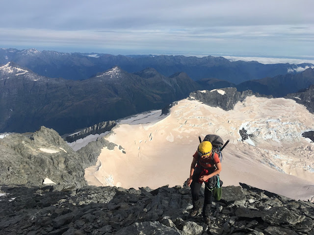
Crossing the snowball glacier, the shoulder of Mt Lydia in the background (Maddy Whittaker)
Tom and the rope soloing the rock step near Arawhata saddle (Maddy Whittaker)
The next day, we began early sidling steep tussock, Mount Ionia and its incredible glaciers watching our progress from the other side of the Arawhata Valley. Our route to the snowball glaciers made its way around the bottom of the Snow White glacier before heading up a steep scree slope then crossing the glacier up higher. Unfortunately due to the scarily rapid nature of glacial recession, we were faced with a massive lake barring our progress. The icy blue water was filled with the sadly thawing icefalls from this incredible glacier. However, not to be deterred, we spied a sidling route below point 1539, placing ourselves on a stunning and mostly negotiable ridge line leading to Mystery Col. At the col, a perfect alpine lake reflected the snowy peaks above us, we drank up the water and stoke before continuing. After this, things started to feel a lot more alpine, we were scrambling along exposed rock steps, flanked by incredible tumbling seracs and the silent torrents of massive glaciers. The sun set over the distant peaks as we reached our next bivvy, in the snowdrift range tops, on a shelf of rock above the snowball glacier.
Tom and Torea contemplating the glacial lake at the terminus of the Snow White Glacier (Maddy Whittaker)
Ascending the ridge after Mystery Col, Pivot Peak straight ahead, the Upper Snow White Glacier to the left (Maddy Whittaker)
Tom and Torea approaching our bivvy near the snowball glacier (Maddy Whittaker)
The night proved a cold one, with our gear freezing in the tent vestibule, but the next morning brightened up clear and bright. After crossing the vast snowball glaciers, the shoulder of Mt Lydia began to loom ahead. With 400 vertical metres of steep snow and huge icefalls, this was the big question mark of our route across the snowdrift range that had been on our mind for days. Maddy confidently led the charge upwards through thickening clouds, zigzagging her way through the icefalls by sticking to the steep snow faces. All conversation reduced as we entered that "no fall zone". We gradually negotiated our way up the slope, hearing only the gusts of winds and the sound of crampons plunging into the face. The elation at the top was a big moment, it went! We dropped down the other side, weaving our way through incredible blue expanses of ice, mesmerised by towering seracs, sculpted monoliths of ice. These places constantly fill me with inspiration and amazement as well as an overwhelming gratitude that we are still able to explore them.
The nature of the wilderness we were in was to constantly present our team with new challenges: rock steps, glacial lakes and numerous moments where we got stuck trying to solo up precarious cliffs clinging to vegetation. However, the constant learning of how to overcome, go around or just grit your teeth and downclimb your way out of a pickle was an amazing aspect of this adventure.
Tom and Torea downclimbing their way out of a pickle (Maddy Whittaker)
As the day drew to a close, the weather worsened with swirling clouds and a strong wind rushing towards us. We scrambled along an exposed ridge top, hoping to make it to somewhere less high to sleep that night. However, we were continually presented with cliffs and unstable scree preventing our way down. After some scary attempts to negotiate the bluffs, we decided a high bivvy was a better option. Another cold night looked to be on the agenda.
The next day brought the weather in properly, claggy clouds reduced our visibility to a minimum, however, refreshed by sleep and food, we navigated our way off the tops and descended rapidly towards the Dart Valley. An incredible rainbow appeared in the valley. Nothing could match that feeling, the route had gone, we'd ticked off the whole snowdrift range, we were getting down to the Dart, happy days. Despite having 500m vertical metres of bushbashing, 22km of the Dart Valley and no way to get back to our car in Wanaka, this story is already too long so that’s where it will be left.
18/2/2020 - 19/2/2020 Party: Torea Scott-Fyfe, Tom Hadley I'd just arrived back in the South Island and Torea had just finished 12 days of fieldwork when we met in Wanaka. There was 2 days of workable weather ahead of us and we were both ready to get stuck into some mountains. Tom: “Hmmm well the Raspberry flat road is open again”, Torea: “Oooh yes we could climb some domes”, Tom: “Hmmm how about climbing the big dome...?”, “Yes let’s climb Mt Aspiring!”. The next morning, we set off with light packs and lighter legs from raspberry flat at 8am, jogging and walking along the expanses of the Matukituki valley. The open grasslands soon turned to beech forest, then to scrub as we carried on. We arrived at the waterfall in 4 hours time and began the push up to Bevan col. After negotiating slabs and bluffs, the expanse of the Bonar glacier spread itself out before us. We moved our way through gurgling blue crevasses to arrive at an empty Colin Todd hut, how good! At 5am the nex...
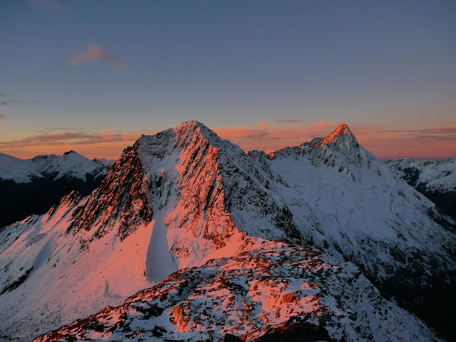
Crossing the divide into the Landsborough (Easter 2019) (Maddy Whittaker) Our mountains, how they bend and fold. Glaciers flowing from rock to ice to me. This past year I have been mesmerised by the scale, the shapes, the way light plays upon the ice and the patterns the wind whittles in the snow. I used to think it was a strange force that draws us upwards. But now I understand that this force is not so strange at all. Some moments seem to burn brighter than others. The first time I saw the Bonar glacier, clambering over the top of the Quarterdeck, the golden moonlight and pink rays of first light washing the snow in a magical glow. The first time I scrambled upon warm granite in the Darrans, impossibly steep rock expanses rising straight up out of the sea. My first New Years in the hills, running through golden tussock, my memories tinged with the overexposure of golden hour. My first trip deep in the bowels of the Landsborough. Water cascading everywhere in a wild...


Comments
Post a Comment