Swimming Lessons on the Dusky and Other Stories: A Southern Fiordland Traverse
 |
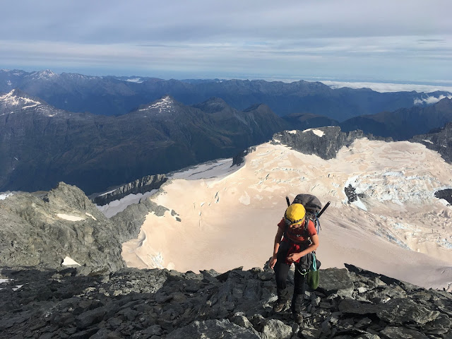
| Traversing from Mt. Watson to Mt. Ward (Luca K) |
Party: Sam Waetford, Olivia Truax, Maddy Whittaker, Tom Hadley, Luca Karjalanein
When a trip starts with Tom breaking into my house at 4am to wake me up after I slept through three alarms - you know it's going to be an interesting one. Hiccups behind us (or so we thought), we made our way over to the Borland road in South Fiordland.
Less than an hour after leaving the car, we found ourselves soaked to the bone, standing beside a huge brown raging torrent (the Grebe river as seen in the video below) - which we would clearly not be crossing. Back to the car we went and out came the maps - time to plan a different route.
We decided to head up the "elevator" (the powerline road to the Manapouri power station that cuts out any bushbashing) and hit the tops from there. The plan was to traverse the Wall and Townley ranges and meet up with the Dusky at Centre Pass, which we would walk out along. It was Sunday afternoon by now and we had two days of good weather to be on the tops.
After pure slog, we headed off the 4WD track at Percy Saddle and headed into the proper hills. It was dramatically misty as we veggie soloed some notches in a ridge that fell away to a mysterious lake far below. We found a camping spot just as the rain came in hard and all crammed into Sam and Olivia's tent for dinner. Sam had dehydrated a pasta meal and it was incredible. "I just dumped random bits of butter, oil, protein powder and milk powder into the sauce," he explained.
 |
| Some of the flatter day one travel, not far from where we camped (Maddy Whittaker) |
 |
| Maddy, Tom and Luca waiting for dinner to rehydrate (Sam Waetford) |
Luca, Tom and I were sharing a tent. We knew it could only fit two sleeping mats so we'd talked about how we'd share two as a three - no problem. As we set up camp for the night, it was discovered that Luca understood this as he'd have his mat and Tom and I would share one. And so began the first of a number of nights of attempting to share Tom's narrow sleeping mat. I woke up the next morning lying entirely on the ground.
Day two started with the realisation that the ridge we'd been looking to traverse to Mt Grey would not go. Instead we could drop a significant amount of vert down and then climb up a waterfall, gaining the ridge just past the impassable notch we could see. As we climbed out out of the waterfall we found this emerald lake. It felt like no one else had ever been there.
 |
| Remote lake (Maddy Whittaker) |
The rest of the day was a mix of snow, being snowed on, constant navigational challenges and slow transalpine travel (1km an hour yehooo). But the world that was unfolding before us was something incredibly special.
 |
| Olivia approaching a saddle on the ridge (Sam Waetford) |
 |
| Tom and Luca on what we fondly called "Christmas Peak" as it was snowing in such a Christmassey way (Maddy Whittaker) |
 |
| The ridge we were following (Sam Waetford) |
 |
| The boot skiing game was strong (Sam Waetford) |
 |
| A flock of 15 kea flew by in the mist (Maddy Whittaker) |
 |
| Sam map reading at some point on the ridge (Olivia Truax) |
 |
| Maddy and Olivia nearing hour 12 of the day (Sam Waetford) |
Now one of the biggest lessons I was learning this trip was how much snacks is an appropriate amount. The last few trips I'd taken too much food, and this time I'd come to discover I had overcompensated, taking far too little. Two museli bars a day for snacks when moving for 12ish hours a day is not enough. I slowed dramatically as the day came to an end and it took almost all of my willpower to not dip into tomorrow's rations as we waited for dinner to rehydrate.
 |
| Frosty kea attack (Sam Waetford) |
Day two dawned frosty. Despite being in our tent, our boots had frozen. A layer of ice was over all of the tents. And thankfully Olivia's walking pole, which had been attacked by kea - however their beaks had only left scratches in the ice on it. Within a couple of hours we were on top of Mt. Watson, beautiful views in all directions. It was a bluebird morning. The calm before the storm. We had about 12 hours until the rain would hit.
 |
| Maddy on Mt. Watson (Luca K) |
It was at this point where we looked over to Mt. Ward and realised the bit on the map which looked like it would go, was not going to go. No where in view really looked like it had potential (we had decided not to carry a rope or any gear so couldn't protect anything), so we went for a wander round the corner to see if we would find anything there.
 |
| Sam and Tom traversing round the corner (Luca K) |
And there it was. A couloir which was still filled with a stretch of snow. Our stairway to heaven. At the top of the snow, there was some death choss to navigate - the kind of scrambling which blurs the line of scrambling and very easy climbing. I was loving it. This was definitely the most fun bit of the trip so far.
 |
| Stairway to heaven (Maddy Whittaker) |
 |
| Maddy kicking steps up the couloir (Luca K) |
 |
| Traversing off the snow onto the death choss (Maddy Whittaker) |
Just like that we were on top, heading for Mt. Ward. We could see the sea from here. And the clouds above the sea - the sky turning grey as the weather moved in. A storm was coming.
 |
| Just past where the couloir met the ridge, heading towards Mt. Ward (Maddy Whittaker) |
 |
| Sam and Olivia beneath changing skies (Maddy Whittaker) |
We wanted to get down to Centre Pass in order to get off the tops and onto the Dusky with minimal bush bashing. To drop down to Mt. Memphis however, required descending and sidling a number of high consequence tussock and snow slopes which we couldn't really see if they linked up from above. They did thankfully, and soon we were almost at Centre Pass.
In my mind, that black dotted line on the map was going to be smooth sailing. A mindless "track" after days of slow travel. I quickly discovered the Dusky is barely a track. It is more of a swamp or bog than anything else. You learn that trying to avoid the shin deep puddles and knee deep mud is pointless.
As it got dark, we trudged through the rooty, muddy, wet, slimy track, feeling like the hut must surely just be around that corner. Oh man, it was a blessed moment when that hut came into view. We were the first people who had been at the hut in quite a significant period of time.
It started raining. Hard. We read through the hut book.
Sam: "Only one group has ever been turned around in here, on the first side stream crossing. We'll be fine then."
......
It rained a lot overnight. And that next morning. Over 150ml actually, something we didn't realise until later. We got to the first side stream, a km from the hut. It was not passable. Not even in the slightest. The main river was a death flow, the side streams were just narrower death torrents. After scouting up and down, we found a log bridge to cross. That's the hardest crossing down we thought. Oh we were wrong.
 |
| Tom crossing the Wyne Burn (the first side stream) (Sam Waetford) |
 |
| The Wyne Burn joining the main river (Sam Waetford) |
As it rained more and more, the previous days complaints about shin-deep water seemed silly. It was knee-deep and now waist-deep. And then it was chest-deep in places. And then there were some short sections which we swam. We weren't sure we could get back to the hut if we wanted to now, so we kept going forward, as the main river slowly swallowed the track we were walking on. (Note: there was always side bush going up a hill which we could have bushbashed up to stay above the water level if we had got trapped, so weren't ever in too serious of a situation).
 |
| Maddy crossing a 3 wire bridge (Sam Waetford) |
 |
| Maddy wading along a shallow section of track (Sam Waetford) |
Now having seen no one in four days, we did not expect to run into another party in this kind of weather walking in. However, here they were - a team of three from Christchurch, planning to go up to Centre Pass and do the original traverse we'd had planned and had had to abort due to not being able to cross the Grebe.
"There's a 3 wire bridge we came across about an hour ago, " they said, "it's been washed out. The tree holding it up on one side fell over. We crawled across the tree but we think it will be underwater when you get there. Good luck!"
The tree that had crossed was indeed underwater when we got there. However we found another bigger tree. It's amazing comparing the photo of me crawling across it (see the silver in the water where the mangled three wire bridge is), to a photo of the same tree which our friend Jamie took a week later. There is over a metre of solid water difference between the two.
 |
| Maddy crawling over the tree (Sam Waetford) |
 |
| Jamie's photo from a week later. The top log is the one I was crawling across. It was barely out of the water when we were there. (Jamie Gardner) |
It was 4pm when we got to West Arm Hut. The DOC time for what we'd done that morning was something like 5 hours. For the first time in my life, I'd been slower than a DOC time - and not by just a small amount - by hours. We got the jetboil fired up and ate lunch, trying not to think about the fact all our clothes were soaked (Sam's phone was drowned - to be partially resurrected by the dehydrator later), everything in our packs were soaked, we had basically no food and we had 800m elevation gain and ~17km to the car.
 |
| Luca and Tom with 1000 yard stares in West Arm Hut (Maddy Whittaker) |
As we set off in the pouring rain on our final 17km 4WD track slog, we decided a distracting game of countries beginning with A, B, C etc would be a good idea. We went through the whole alphabet in great detail and reached Z before we'd got to Percy Saddle. At least here the rain stopped and we began yarning about climbing again. We werre in good spirits, plugging away at the kms. It was 10:30pm when we got to the car.
I noticed something stuck under the windscreen wiper. A note from the Manapouri powerstation crew saying something about a washed out road. Of course there's a washed-out road. After a day like today, why wouldn't there be one. I showed Sam and he just started laughing.
We drove upwards to where we found two abandoned vehicles. We drove past them, hoepful that maybe the washed out road was passable. Conclusion: it was not.
So we camped and decided to deal with the situation the next day.
By the next morning, we were feeling our empty stomachs. Why hadn't we left food in the car?
We ate a handful of oats we had left, and then "generously" gifted 9 peanuts (4.5 each) to Tom and Olivia who were going to run the 25km out to the Borland lodge.
 |
| Getting ready for our ration of a spoonful of oats. Yum! (Sam Waetford) |
So while Luca, Sam and I played chess (turns out Sam is very good at chess), they headed off. They were picked up within about 7km and taken to the lodge where they later showed us they were fed creamy pasta and given biscuits and all these incredible things. Meanwhile Sam and I had checked out the parked up cars. The rental was full of food but was locked, and there was no sign of the key under the wheels. Turns out the occupants of the cars had been flown out by heli the day before.
Eventually, a digger made it's way out from Te Anau to clear the road. We finally were able to drive to the metropolis of Otautau and get food. Oh beautiful wonderful food. Having had this trip and the Mt Somer marathon in the space of a week, I'd lost over 5kg. So had everyone else too it seemed.
It was a wonderful trip. One of the truly good ones. Next time however I'm bringing more than two museli bars a day. That was just stupid.
 |
| The digger working its way through the sludge pile (Maddy Whittaker) |


Comments
Post a Comment